 |
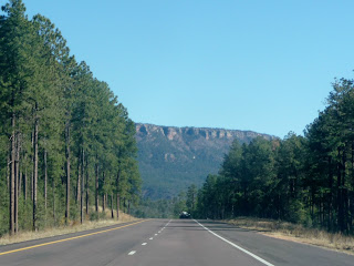
| Photo- The northern edge of Tonto National Forest. |
As I headed east the landscape of Tonto National Forest changed
from tall cactus to tall pines on bluffs.
There were forest spotted mountains off in the distance. The road started to climb and I found myself in
mountainous country of the Sitgreaves National Forest in an area called the
Mongolian Rim. It’s a HUGE valley area
but I didn’t really have a viewpoint off the side of the highway as I headed
first east. It was amazingly beautiful
but I could risk taking photos and keeping the road on the climbing curvy
roads; sorry. But I’ll tell you it was
an amazing view.
Before the town of Heber-Overgaard I came upon a prescribed
fire. Yes, the forest service burns on
purpose so as to kill some of the undergrowth that can lead to more dangerous
situations if a real forest fire raged.
This one did appear to be under control.
The traffic slowed. There were
fire trucks and police vehicles on both sides of the road with their lights
flashing. Men with yellow vests were
running around with shovels in hand while the smoke just sat around the
road. There was no wind and that’s a
good thing in this case.
 |
| Photo- The precribed burn area I drove through. |
As I entered into Heber-Overgaard, I turned right onto Hwy
277 to head north. I was tempted to go
straight. There was a Wild Girl’s Saloon
advertised that sounded like a good place for me to stop for lunch; I figured I
just might fit in too! But it was a
little early for lunch yet so I pressed on.
Seven miles later, I came to “T” in the road and turned left onto Hwy
377. Shortly after that I saw the sign
that I was leaving the Sitgreaves National Forest. The landscape changed drastically to a very
arid land with short juniper trees and golden wheat colored grasses. Another 30 miles later and a quick left and I
was in Holbrook just off of Interstate 40.
Next was the Petrified Forest that was just off of I-40
another 25 miles down the way. The park
wasn’t busy. In fact, I asked the gal if
there was a film to watch at the visitor’s center and she said yes, and she
could put it on just for me if I wanted it.
I was the only one in the room as the film played. The film gave the history of what the area
was like and how the petrified trees got to where they are today. It also stressed that nothing in the park was
to leave the park unless it was purchased from a gift shop. This is probably the most erosion that occurs
at this National Park; visitors take part of the park home with them and little
by little the park disappears. They also
warned that they do inspections and it’s a crime to take anything from the
park. It was repeated a couple of times
in the film and I was told by the national park employee again just before I
left the building. Okay, I think I got
it.
 |
| Photo- My first sighting of the Painted Desert. |
I drove north from the Painted Desert Visitor’s Center to
the Tiponi Point where I got my first real view of the Painted Desert. You know, I’ve seen some photos of it and
some artist renditions but I just thought that they had played up the colors
and nothing could be like that in real life.
Boy was I wrong. In front of me
stood the small grooved hills with lined layers of bright vibrant colors. I could see why they called it the Painted
Desert. I stopped and took a few photos
and hoped that they would begin to do justice to what I was really seeing.
 |
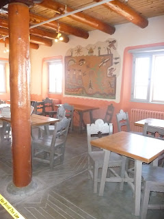
| Photo- The dining room area of the Painted Desert Inn. |
I was excited to get to the Painted Desert Inn; a National
Historic Landmark that in the 1950’s was in its heyday of a stop along Route
66. Yes, I’ll admit I knowingly stumbled
upon another section of that famous highway. There used to be a popular restaurant and
soda fountain bar inside. Now all that
was operational was a book shop.
I parked the car, took a couple pictures of the outside and
then went in. Wow! The vibrant blue paint against the adobe
jumped out at you. The murals in the
dining area had been restored for me and future generations to see. They were wonderful. The area of the fountain bar with the stools
stood gleaming. A glass paneled ceiling
area was above the stairs where symbols of the Zuni and Pueblo people were
stamped on the glass and painted. It
was all so colorful and vibrant. I had
seen black and white photos and a few small colored photos but none did it all
justice.
 |
| Photo- The Route 66 stop in the Petrified Forest Nat'l Park. |
I had just mainly planned to drive through the park and
visit when my interest was sparked. I
drove along the road in the park and stopped at a couple more overlook
points. The road moved away from the Painted
Desert areas and became flat filled with scrub brush. Then there was a Route 66 area just before
the park road went over I-40. There was
a great deal of visitors there; so I decided I would stop on the way back. I drove on.
The road continued on for almost 5 more miles with the scrub
brush land. Then off in the distance on
my left I could see the same hills of the Painted Desert only this time the
hills were gray with thin layers of black and burgundy. The road turned and dipped. There was a bridge area with a wash filled
with bright golden trees against a barren flat land. I thought it was wonderful scenery and
probably the only one. I stopped to take
a picture. I thought it was like Fall in
the desert and in its starkness I saw beauty.
 |
| Photo- One of the roacks at Newspaper Rock. |
As I drove along, I saw a sign that said Newspaper Rock. I swung my car down the road and parked. I walked over to a cement lookout point and
saw a jumble of rocks. But upon closer
inspection there were petroglyphs on the sides.
It was kind of hard to see with the naked eye and there was an eye piece
that helped you zoom into see them. All
the signs stated to stay on the platform.
This was as close as you got; which was a bit disappointing. I continued on.
 |
| Photo- A gray version of the Painted Desert. |
Next, it was the area called the Tepees. The Painted Desert hills had more of tall
upright shape here. I guess you could
call them tepee shaped. I drove on and
pulled into the Agate Bridge. Now this
was a total disappointment. The Agate
Bridge was being held up by a bridge of formed concrete. Whose bright idea was this? I found it disturbing that I was in a
national park that should be preserved and there’s formed concrete holding up a
natural bridge. I would rather have the
natural bridge not be than to witness the bridge being supported by formed
concrete. I read a sign nearby and they installed
the concrete bridge back in the 1950’s.
 |
| Photo- A log of Petried wood in the Crystal Forest. |
Shortly after that I arrived at the Crystal Forest
area. All signs said to stay on the path
but two older women were not on the path and taking close up photos of
petrified logs near the parking lot area.
I guess they didn’t understand the leaving no foot print idea of a
national park and I ended up seeing three other people doing this too as I
continued on the path. I found it very
frustrating; because in this day and age there is a thing called zoom on most
cameras and there were logs that were very close to the paths too. The whole area seemed like a forest of downed
short cut up logs against a gray landscape.
Some of the logs had the most amazing colors in the centers of them. I walked along the path and drank in the
interesting landscape with the quietness.
 |
| Photo- The Crystal Forest. |
Next, I drove towards the south of the park where there was
the Rainbow Forest Museum. There was
more traffic here. I decided I needed to
turn around before the park closed. The
parks hours go till 5pm and I wanted to make sure I was by the north entrance
before then. I swung by the Route 66
stop on the way back. There was an old
car, a cement formed bench that had car tail lights on one side, and a sign
with information about Route 66. Route
66 in this area had been torn up when they built I-40.
As I approached the north entrance there were signs about
stopping for a mandatory inspection. I
wasn’t worried but was wondering how far they would inspect my loaded down car. They might be a while. I stopped at the stop sign but there was no
one there. I drove past the visitors center
and on to I-40 heading east onto Gallup which was about 70 miles away.
The landscape changed from the barren flat scrub lands to
towering colored rocks. The road climbed
up and then went down but in general it was all a gain in elevation. I watched the sun climb up the sides of the
towering rock as I drove east. The sky
in front of me had hues of chalky pink and lavender. It was a wonderful view with the edges of the
towered colored rock gaining more red hues as the sun descended. It was a disappointment when the sun did
finally set.
 |
| Photo- The sun starting to set on the towering colored rock landscape. |
I got checked into the hotel and ended up in the north area
of Gallup at a local Italian place for dinner called Fratelli’s Bistro. It was a casual easy going place where I
instantly felt at ease. I had the Vodka Sausage
Rustica, which had a wonderful creamy vodka tomato sauce with pieces of spicy
sausage over a bed of farfalle ribbon pasta and a glass of wine. For dessert I could pass up their homemade
gelato which they had 12 different flavor selections to choose from. My server told me that when the owner’s wife
was pregnant they made a pickle flavored gelato for her. Pickle?!??
I think I’ll past on that one.
I watched the election results starting to come in on TV,
while I enjoyed my gelato. This would be
the first time since I was 18 that I didn’t vote. It felt rather strange but at the same time I
really wasn’t enthused about either candidate.

No comments:
Post a Comment