Showing posts with label Crater Lake. Show all posts

Sunday, October 7, 2012

DAY 46- Lake Tahoe...

I always knew that Lake Tahoe was a lake that was on the border of Nevada and California but I never really thought about the size of the lake.  It’s just a lake, I always thought.  I had no idea of how big it was or anything else about it.  I was surprised to see how big it really was.  It measures 12 miles wide at its widest and almost 22 miles at its longest and has almost 72 miles of shoreline.  Now that’s a big lake!  I was also surprised to know that Lake Tahoe was the second deepest lake in the US; the first being Crater Lake.  Gee, now I can write off visiting number 1 and 2 on the deepest lakes in US. (Maybe I should find out who’s in third? Hmmmm…. I would really laugh if it ended up being Utah Lake.)
Photo- Lake Tahoe as seen from a city park along the beach.

Lake Tahoe promotes itself as a great place to play year round.  During the summer a great deal goes on the lake and in the winter there’s skiing.  There’s also a fair amount of activity that goes on yearlong at the casinos on the Nevada side too.  It’s climate I’ve been told is very nice too.  But it does get cold enough for snow in the winter and it gets a fair amount of that; as witness by the tall red FH signs, near all of their fire hydrants.

I got up in the morning, grabbed a quick bite from the hotel’s breakfast bar, and off I was on my bicycle roaming the streets of South Lake Tahoe.  I first ventured down to the beach near my hotel.  From there, I slowly started to make my way around the lake clockwise.  The night before I had found a Lake Tahoe bike ways map at a local visitor’s center.  I was using this as a guideline but there wasn’t a great deal of detail and the map was not to scale in quite a few areas.  I wondering through neighborhoods only to discover dead ends or the road would dead end but there was a bike path that connected to it. 

There actually was quite a system of bike paths combined with bike routes through neighborhoods that helped avoid the heavier traffic roads.  It just took a bit to figure it out as I went along.  Unfortunately, there was that construction on Lake Tahoe Blvd which affected a nearby bike path too.  It got a bit hairy there for a few blocks but after that it was fine.
Photo- Rustic neighborhoods of South Lake Tahoe.

It was fun going through the neighborhoods.  A great deal of the houses looked like rustic cabins; all sizes and shapes.  All of the properties had large trees on them and sometimes I would even go by a neighborhood street where there would be a large tree in the middle of the road.  I came through to a neighborhood called Tahoe Keys.  The back of most of these homes had access to water for the owner’s boats.  It was kind of cool because I could see the lake here and there between the houses.  I bet some of these houses had some amazing views.
Photo- An area in the Tahoe Key's neighborhood where there was space between houses.
Photo- An example of some of the open spaces in Lake Tahoe.

I went further west along the Lake Tahoe there were pockets of open space land.  Some of it was marshland, some was National Forest land, some were beaches, and others were park areas.  The bike paths went through quite a bit of these areas and quite often there were wooden bridges that I cycled over.  It was some wonderful scenery. 

I eventually came to where the bike path went along Hwy 89 going north on the west side of Lake Tahoe.  I went through an area known as Camp Richards where tents were being set up for an Oktoberfest they would have in the next couple of days.  There were pumpkins set out all over the place and it was looking really festive and Fall like.

I continued heading north on the bike path.  There was more and more National Forest land.  It was beautiful but you couldn’t really see the lake at this point.  There was however a bridge area that I came to where people were stopped and watching over the railings.  It was here that I happened upon the Lake Tahoe’s red salmon.
Photo- Lake Tahoe's red salmon.

I was told the night before that I should come see these fish because this time of year in their cycle they really did turn red.  It was cool watching them swim around in circles.  There were a lot of them.  Periodically a leaf would fall on the surface of the stream and one of the salmons would jump up out of the water towards the leaf. 

I continued north to where the bike path crossed Hwy 89.  I decided to turn around because that would put me at 35 miles.  That was enough for one day.  But before I turned around, I admired some quaking aspen that just had a hint of yellow.

After a quick shower, I headed out in the car with the idea of a possible hike but I was really just interested in seeing more of the area.  I ended up driving north on Hwy 89 past where I had turned around.  From there the road started to climb and got curvy; and yes, of course, scenic.  The road had a fair amount of traffic and there were a few brave cyclists along the stretch too.  There was virtually no shoulder on the road and a metal road guard in only a few of the places.  It was hair pin turns for the next 7 miles. 
Photo- Emerald Bay with an older mansion on the beach.

I came to a viewpoint that overlooked the Emerald Bay part of the Lake.  It was beautiful and kind of reminded me of Crater Lake with a little island in the middle.  I stopped.  It was here that a guy was standing next to a loaded up bicycle with a turned up hat singing America the Beautiful while everyone was taking pictures.  It looked like he had a fair amount of money in his hat.  Hmmm… that’s an idea to supplement my trip money.  Not sure if my voice is good enough for that though.

I continued driving around the Lake.  There was more climbing hair pin turns but at least these had a bit of a shoulder.  It was getting pretty high.  The landscape was turning rocky with pine trees; mostly big rocks.  Then, there were large sized houses with several floors looking out over towards the direction of the lake.  You could see the lake here and there through the trees. 
Photo- Lake Tahoe as taken from an eastside overlook area.

Then came some smaller communities where there were houses and a few businesses.  They were rustic and quaint.  I continued on and the road opened up to views of the Lake.  The bike path was back along the roadway and several cyclists were out enjoying it.  There were people in boat and others playing with their dogs along the beach area.  It was a slightly overcast day but it was still a nice day. 

I drove around the whole Lake.  The north part had a small old dam area.  There was more business and quite a few smaller and more expensive hotels or at least they looked expensive.  The west side of the Lake was disappointing.  The road turned into an Interstate and there just wasn’t as much going on along that stretch.
Photo- A cyclist out on the bike path along the beach of Lake Tahoe.

Now I was ready for a late lunch or an early dinner.  I stopped by a place I had seen earlier while biking.   Riva’s Grill had a nice outside back deck area that over looked the Lake and the Tahoe Queen docked there too.   It provided plenty of people watching and scenery.  It also happened that I was 4 minutes away from the Happy Hour. Yeah!  Half price well drinks and half price pizza or appetizers.  I ended up talking with a retired couple next to me that were celebrating his 71st birthday.  We toasted and chatted.

Next, I went in for a quick look at some local art galleries next door.  One was a wonderful photographer where I ended up talking with his wife who was manning the shop.  They liked to travel and he liked to take pictures.  One thing led to another and his travel hobby became a business.  I really liked his photos and there was some wonderful combinations matted together that were very reasonably priced.

Next, I was in bad need of a manicure.  Back at the hotel, I decided to walk across and along Lake Tahoe Blvd.  There were all kinds of shops and I saw a couple of nail places but they were closed.  Another salon told me they had already sent home their manicurist.  I finally found one that was open.  Sure, they could help me out.  Lisa a cute Oriental woman cheerfully helped me.  She said she liked my laugh and that I seemed happy.  She talked me into getting a pedicure too.  Sorry Cousin Kimmie!  I’ve been thinking of you every time I look at my toes but for only $5 more I could have both.  I also would be matching too!  I hope you’ll forgive me.

Lisa was in the middle of my manicure, the closed sign was turned over.  Now, I felt bad about her staying late to do my ugly feet.  But Lisa said it was no problem and was asking if I was going to go out to the casino tonight.  I said I was thinking about it.  She said that now I would have to because I had lucky nails.  Crack me up!  Well, how could I say no to that? 

She finished my feet and gave me these disposable thongs to walk over to the drying lights near up front.  After a bit, she mentioned that if I wanted to I could walk with those to my hotel if I wanted to.  I’m like 6 blocks away at this point.  But she said that it would be no problem for me to stay and wait while they dried.  Now, I felt guilty so I said that I should be okay to walk.  I walked down 1 block to the corner, along busy Lake Tahoe Blvd for 2 blocks, and waited for the light to change in the crosswalk.  All this while shopping stores and what not are open.  People are walking by on their way to the casinos a couple blocks further along.  I felt strange carrying my shoes and running around in disposable thongs but no one else seemed to give me a second look or said anything.

I got to the hotel which was 3 more blocks and now I just HAD to go to the casinos.  I had to give my lucky nails a shot!  Off I went to the casinos.  I walked through the first casino, Harrah’s; but I didn’t like the feel of it or their bar areas. I had heard that the other casino, Montebleu, had the loosest slots.  Not that it really makes a difference.

I got to Montebleu and found the Center Bar; which I did like.  I ordered a rum and coke.  I sat at the round bar and people watched.  A majority of the people looked to be just barely 21.  In fact, the bartenders were checking quite a few of the ID’s to make sure.  I ordered another drink and continued to people watch.  A rowdy noisy bunch of kids came in and sat next to me.  I moved my chair over.

As I was getting ready to order my third drink, a young cute guy from LA starts chatting me up.  We talk for a bit and he mentions about the dance club in the casino having a Ladies Drink Free Night.  So I heard the rumors, I said.  He asks my name shakes my hand, says his name, and says I’ll see you later at the dance club.  I just smiled and thought Nope!  I wasn’t in the mood to dance tonight and I was just planning on doing a bit of slots and then heading back to the hotel.

I put in $15 in various slot machines and it lasted me over 2 hours.  I was getting tired and finally cashed out having only lost $12 but having consumed about 6 smaller free rum & cokes.  It was time to call it a night.

Saturday, September 22, 2012

DAY 31-32- Bike Ride, Museum, & Family...

DAY 31- A Bike Ride and Logging Museum...

Photo- Bike path in Klamath Falls near where bike paths meet.
It was beautiful blue skies with not a cloud in the sky and the temp had risen to mid-50’s; as I jumped on my bike to explore the Klamath Falls area a second time.  I will say that Oregon in general is a very bike friendly state.  I was finding that the area of Klamath Falls was holding true to that rule too.

Klamath Falls has 2 main paved bike paths; one that goes along the city’s canal for about 6 miles and another that goes through the heart of the city and out to a small town called Olene.  The 2 paths meet at a bridge where they form an “X” and they make quite a bit of the city accessible via these paths.  There are sidewalks from various neighborhoods that meet up to the path and there are even other short paths that go into other parks or neighborhoods.  All of these path ways are reclaimed areas where the railroad used to be.  There are even additional unpaved trails that spread out from these two paths and if you had something other than a road bike, like me, you could go for miles and miles on this system of trails and paths.    
Photo- The Amtrak Station in Klamath Falls.
There are also quite a few street areas that have painted bike lanes in them too.  While trying to find where the second path started, I happened upon the Klamath Falls Amtrak Station.  I thought that was rather interesting that there was a station here.  But I guess there is a fair amount of tourist business that goes to nearby Crater Lake and commuters from the surrounding areas that use the train.
Photo- A big yard with a big garden along bike path.
Photo- A duck in the canal along bike path.

As I rode along both of these paths, I noticed all kinds of things.  There are a mix of big yards with gardens, ducks on the canal, schools, city swimming pools, farms, warehouses, RV resorts, lumber yards, nice neighborhoods and not so nice neighborhoods.  You almost felt like you were in the country in some areas even though you were only a ½ block away.
Later on, I went to the Collier State Park Logging Museum.  It’s about 40 miles north of Klamath Falls on Hwy 97. (Crater Lake’s south entrance is about 65 miles north of Klamath Falls.)  This museum is more of an outdoor display than the typical standard museum.  During the height of the summer they have state park employees that do demonstrations and give more guided tours of the area.  Well, as per my luck, I was two weeks late for all of that.  So I opted to borrow a map from the state park employee who was manning the information/gift shop and do my own self-guided tour.
Photo- Used to be drawn by horses and used to transport logs down the mountainside.
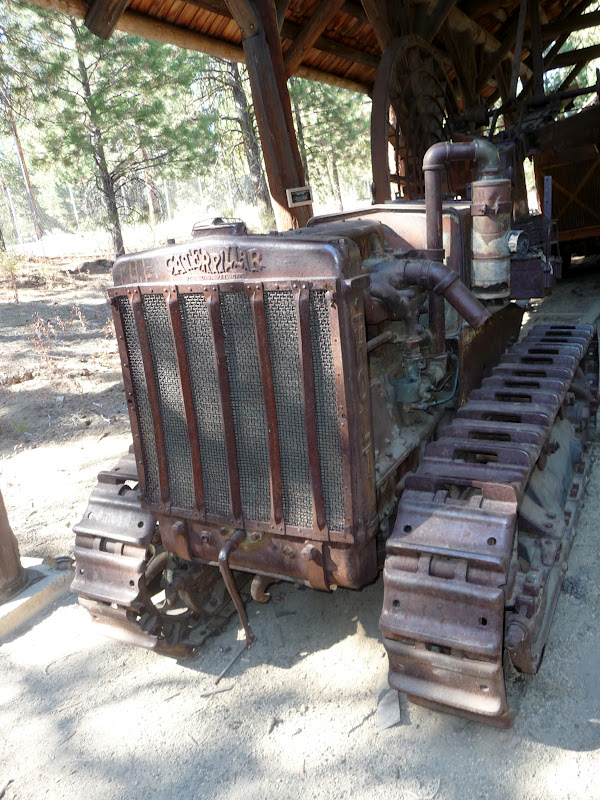
Photo- One of the first Caterpillars.
Photo- AND the $64,000 question is.... What's a RIP SNORTER?

The museum is set up with the history of logging in Oregon which started in the late 1860’s.  Logging in the late 1860’s consisted of hand tools and wagon-like vehicles where horses were used.  There were all kinds of examples of these items outside under pavilions.  Then, near the turn of the century steam came into being and steam-powered engine orientated machinery came into use.  These pieces of machinery were larger and were generally sitting out in the open.  Next, it was the combustible engine and the logging industry progressed on into our current time.  Most of these pieces were out in the open and on display. 
Photo- A restored original cabin of what the first loggers would have lived in.
There was also a cabin village area to show how most of the men would live while they were logging.  Most of these cabins were one room, with dirt floors, and hew from logs.  They were generally about 10’ x 14’ with a slanted roof.  It was a very interesting place to visit and it was just a very pretty day out.  It was nice just to be out enjoying it.

DAY 32—A Day Off and Family…
I know, I know… I had just taken off another day off just a few days ago and come on it can’t be that hard to be on a basically permanent vacation.  What’s up with that??!?  Well, I did need to catch up with some laundry, try to rearrange the inside of my car, and I wanted to do a bit of painting too; plus, I wanted to hang out some more with my Aunt Lindy too.   I managed to get a couple of paintings done and laundry got done too.  I hung out the whole day with Aunt Lindy and that was nice too.  It was a productive day. 
Photo- "Tickled Pink Shoppe"; Watercolor on 9" x 12" paper.
Based on shop I photoed in Portownsend, WA.
But let me say one thing about family; I think that there are more characteristics than just hair color, eye color, and general appearance that get passed on in a family.  What I’m alluding to is that I am now convinced that the genetic makeup for the open-mouth-insert-foot disease definitely runs in my family. Not that that’s bad but I noticed my family has a tendency to speak our minds and sometimes it’s not the most “Politically Correct” way of stating things.  I guess you could say that it’s probably a good thing that no one in the family is into running for political office because they would definitely be up that creek with no paddle and a ten foot wave coming at them.  But I will say that this same “disease” is part of the reason that makes me so dearly love my family too.  Sometimes, I think that it’s the small idiosyncrasies that make people, relationships and families so interesting; and thus, makes life very interesting too.  

Thursday, September 20, 2012

DAY 30 -Rogue-Umpqua Scenic Byway…

I planned on a scenic drive through central southern Oregon for the day.  Grant, Kimmie’s partner, had mentioned a nice route to drive but that it would take a whole day.  So I started out early; skipping breakfast and heading north out of Klamath Falls.  I passed by the Upper Klamath Lake and all of the pelicans.  I took Hwy 140 west after Rocky Point and went past Lake of the Woods and Fish Lake off into new Oregon territory for me.


Photo- Pelicans on the Upper Klamath Lake.

Shortly after passing Fish Lake, I took a right turn on to County Rd #821 on my way to Butte Falls.  I was driving through wonderful scenic forestland.  The road got rather curvy and I started to slow for the turns.  Before I knew it I was coming around a corner and BOOM!  There are cows in the middle of the road! COWS?!?!  Yes, I was in the middle of an open range area which happens quite a bit in Oregon but this was the first time I had actually seen cows on the road.  There were 7 large Black Angus cows in the middle of the road.  I slowed to a stop. 
Photo- HOLY COW!  They're in the road!

The cows just stood in the middle of the road.  HELLO! Move you big animals!  The car that was behind me started to honk and I followed suit; me being a City Girl had no idea what to do with cows in the middle of the road.  Low and behold; they started to move off the road.  Yeah!  As I drove by the cows just stared blankly at me.  I never realized how dumb cows could be.

I drove through the town of Butte Falls and after that the forestland was set back and fenced farms with green fields took up the foreground.  It was very pretty with horses and cows in the fields; with the periodic red barn or unpainted barn here and there. 
Photo- Farms with forest land in the background. Wonderful scenery!

I continued on; thinking that I was still on County Rd #821 but turns out I wasn’t.  I ended up coming out to Hwy 62 about 5 miles south of a cute small town called Shady Cove.  It was 15 miles south west of where I should have come out on Hwy 62.  But that was okay.  I went through Shady Cove where the cop sat right by the quickly reduced speed limit for the town.  I practically slammed on my brakes; to go from 55mph to 30mph.  I even managed a quick smile and way to the cop as I slowly went by.  But I HAD to stop for a quick picture of the pink Phil’s Frosty.  I later found out that it’s the place in Shady Cove to stop and eat ice cream or burgers.  There did seem to be a great deal of cars out front and it wasn’t even 11AM.
Photo- A hot spot and VERY pink place in Shady Cove!
Photo- The Rogue River as seen from a city park just north of Shady Cove.

I went along Hwy 62 where off to the right I could see the Rogue River.  It was a very scenic area with trees starting to change along the river and exposed rocks next to the road.  I drove past the small town of Prospect and on to Union Creek where I was told to definitely stop at Beckie’s Restaurant.  It was either their cinnamon roll or a piece of one of their pies that came highly recommended.  I stopped and I still had about 15 minutes of breakfast being served. 
Photo- A bird just taking off I saw on the Rogue River.
 
Photo- A MUST stop for thier cinnamon rolls or pie!
Photo- The inside of Beckie's Restaurant.

I opted for the yummy cinnamon French toast and hot coffee.  OMG!  It was dessert for breakfast!  It was as I was enjoying my breakfast that I over heard what sounded like Germans trying to learn to pronounce English words.  It was rather interesting listening.  As I was finishing my breakfast and looking at a map that I discovered I was close to a couple of sightseeing view sights.  I figured I could definitely use a bit of hiking to work off breakfast. 
Photo- Natural Bridge- where Rogue River runs under these lava rocks for 200ft. and then comes out.
Photo- Water comes out of Natural Bridge and there are side lava caves.

I did a bit of back tracking and went to the Natural Bridge parking lot.  The Natural Bridge is along the Rogue River and it’s where the river runs in lava tubes for about 200ft.  I grabbed my camera and off I went for the ¾ mile hike where there are viewpoints all along to see the Natural Bridge.  I read about the temperature of the water and how many gallons per minute that went through the Natural Bridge.  It was amazing and you could just hear the roar of the water as it went through the area.
Photo- Rogue River Gorge.

Next, I went by Beckie’s and discovered that while having breakfast I was about ½ block from a view overlook of the Rogue River Gorge.  I grabbed my camera again and off I went down the path.  This path however was packed with senior citizens.  It was a tour bus.  So I tried to slowly work my way through the group to where I could overlook the gorge area too. 

While trying to do that, the tour guide started talking to me.  He talked about how Oregon’s sportsmen’s, being so sports challenging orientated, used to canoe through this gorge area until about 2 years ago the state had to outlaw it.  He never heard of anyone dying doing it but he pointed out that it was seriously dangerous and he could imagine that some of they did die attempting it.  Why he shared that with me?  I’m unsure why he chose to share that information with me and he kept his voice down when he told me about it; so that none of the seniors could hear about it.  Strange.

Rather than turning east when Hwy 62 turned, I decided to continue on Hwy 230 up to Diamond Lake; a lake that I could see when I was on the trolley tour up at Crater Lake.  Yes, I was just west of Crater Lake and heading north.  I thought I want to see that lake from the shoreline.

I was about 6 miles north of there when I saw a sign that said—National Creek Falls with an arrow.  On the spur of the moment, I thought why not.  I turned the car.  I went down the road 3 miles to a sign with another arrow.  It said 2.5 miles on a one lane road with turn outs.  Okay, I thought I came this far.  I drove on the one lane road and only had a pickup truck that I had to wait for in a turnout.  I got to the next sign that pointed me off to the right to a parking area and another sign that had an arrow and said ½ mile hike.  I came this far and hoped it was really an actual waterfall but I continued on. 

Down the dirt path I went.  It hairpin turned down the side of a hill quickly and seemed to go back and forth again, and again, and again down the hill.  Wait a minute; this has got to be more than ½ mile by now.  BUT I continued on the path.  I got to the bottom and saw a couple with three dogs.    I went over a couple of logs and off to my left I heard and saw an amazing waterfall.  I could even feel the mist off of the fall. 
Photo- National Creek Falls a secret hidden off the road a ways.

I petted the dogs, of course, and talked with the couple.  They were from Grants Pass and came here to get away from the heat for the day.  It was as I was leaving that the guy mentioned that he saw a black bear about ¼ mile down on the road when they came in.  Oh, great I thought and here I am walking alone in black bear territory!  Go figure!  Note- It is recommended that you never go alone in black bear territory.  They are more likely to attack lone hikers.  Well, I decided to just book it back to my car, but I figured that if I talked to myself in two different voices that I could trick a black bear into thinking that there was more than just me in the area.  Yes, I really can be that silly and naïve at the same time!

Photo- The view of Mt Bailey on my way to Diamond Lake. 
I’m glad to say I made it back to my car safely and was not a headliner on a local TV news show.  Off I went back to Hwy 230 and continued north to Diamond Lake.  Diamond Lake is a wonderful lake to see from its shoreline.  It also is a very popular area.  There were quite a few boats full of fisherman out on the lake.  I also drove through quite a resort area with restaurant, cabins, and hotel. 
Photo- Diamond Lake a popular fishing place.

I swung by the gas station there to get a bit before I headed back to Klamath Falls.  It was funny because the attendant said that he had waited on a Jeep earlier in the day that was from Utah too.  He asked if it was Utah day and he didn’t get the memo.  I just shrugged my shoulders and smiled.  Then, off south I went back to Klamath Falls.

Tuesday, September 18, 2012

DAY 28- Crater Lake...

The last time that I saw Crater Lake was about 8 years ago.  It was in the early part of July and there was about 4 to 5 ft. of snow still surrounding the lake.  I had pictures of myself, my dog Rocky, and my friend Kory posing with a snowman in our shorts with the lake behind us.  Sorry, the copies of those photos are buried somewhere in a little 5X5 storage unit in Salt Lake City.  So you see, I had some memory of seeing the lake before.

Photo- My first sight of Crater Lake from Rim Village. Wow!
But when I got to the Rim Village and got out of my car, the lake still took my breath away.  It was rather surprising to see it with no snow, and the brilliant blue color didn’t seem quite as brilliant as the last time I saw it.  I think that was due to a couple of factors.  The first is that there’s smoke in the whole area because of the fire up at Sister’s is still burning.  In fact, that fire has now doubled overnight and they are struggling to attempt to contain it.  The second reason it doesn’t seem as brilliant blue is because there’s no snow.  The contrast with the snow and the light that the snow throws off just makes that blue of Crater Lake all that much more dramatic.
Photo- The pretty scenery on the drive but
note smoke making distance sighting hard.

I explored around the Rim village very quickly.  Taking quite a few pictures but not really being able to catch the real awe of the place.  I took the short trail down to Sinnott Memorial Overlook and got an even more amazing view of the lake.  I tried not to look down because I got a bit dizzy from the height.  Inside and behind the overlook area there’s a room with background information about the lake.  I walked along the path area that runs along the lake in the Rim Village area.
Photo- The view from Sinnott Memorial Overlook.
Photo- A photo taken from the Sinnott Memorial Overlook
(without the roof.)
I really had hoped to take the boat ride that goes down on the lake but the day before was the last day of the season that they ran the boat.  Go figure!  So I opted instead to take a trolley tour guide that goes along the rim road.  It’s a little over a two hour tour; stopping along the way and the National Parks Tour Guide explaining things as we go along.  I went to the Rim Village Café and grabbed lunch while I waited for my time slot for the trolley tour.  I ended up having a conversation with a gentleman named Frank who was from Grant Pass.  He invited me to join him and his friend for a 3 hour hike up to Garfield Peak; a trail with a 1000ft climb.  I thanked him and told him I had already reserved a tour on the trolley.  All I could imagine that I would’ve probably slowed down him and his friend.
Photo- Me with Crater Lake.

The trolley tour around Crater Lake is very well worth the $25; and the guide that I had, Dave, was a former school teacher that was cracking puns and jokes along the way.  At one point, he even got out props of a rubber chicken and a huge pair of men’s underwear.  He would make up names of the Crater Lake scientists and what not like; Rockand Debris, who was an assistant to the Lake’s geologist. Dave, our tour guide, kept it interesting and seemed not to mind the hecklers at all.  In fact, one of the hecklers was a man from Texas and later he made a comment about sometimes people will come up with their boats pulled by large diesel trucks and expect to be able to fish on the lake with their boats.  Quite often, they are Texan’s wearing big ten gallon hats.
Photo- Inside the full trolley tour.

The tour guide then goes on to explain that access to the lake is near impossible. There are cliffs along the lake that vary in heights from 300ft to 1000ft.  The boats that are currently on the lake were helicoptered in and placed onto the lake.  They are stored and winterized just off to the side of the lake. 

Yes, there’s fish in the lake that were stocked into the lake years ago and in fact, they have fishing allowed.  It’s quite a hike to get down there to fish.  The fish are not native to the lake and some feel that the fish may have already made an impact on the ecology of the area but the only way to get rid of the fish safely would be to have them fished out.

What cause Crater Lake to be what it is?  Well, the tour guide explained that they believe at one time there was a HUGE mountain thousands of years ago and it had a volcanic episode.  Then, it collapse a bit on itself and over 800 years snow melting has filled it up.  But the interesting thing is because of a pumice area of rock in one of the cliff areas it maintains a certain height of water inside and will never overflow.  The pumice stone cliff area acts as similar as an overflow spout area works in a sink.  Thus, this lake will never overflow and evaporate.

The lake is one of the clearest waters in the world; and has done a clarity test that proved clear all the way down to 144ft.  The only other that comes close is Tahoe Lake which tested to 70ft. down.  The water is so clear because its source is only the snow pack that comes from snow.  There are no underground springs or rivers that run into the crater. The area gets on average 533 inches of snow.  In fact, the tour guide said he took about 800 years for the snow pack to fill the area.

Crater Lake is the 7th deepest body of water in the world at 1,943ft.  The tour guide then did a visual prop of showing how deep the lake was.  He took a picture of the Eiffel Tour, the Washington Monument, and the Statue of Liberty; one right above the other.  He said that there still would be 150ft of water above that.  Across one way the lake is 6 miles and is 5 miles the other way.  The tour guide told a story of how a well known female swimmer had swam across the Lake in 1939.  Of course, she swam the 6 mile distance, she didn't want to be considered a sissy.  (This tour guide had me cracking up!)  It took the swimmer nearly 42 hours to swim across it.

Did I mention I was glad to take the trolley tour around the lake because it saved me trying to drive it?  I’m a bit scared of heights and there were times where off to the side of the road looked like a sheer 300 ft. drop off.  It was more than what my nerves could’ve handled and I’m really not sure I could bike around the lake either because that would unnerve me.  But I was glad to have the bus driver being driving, then I could look up and across (not down) and I could enjoy it.
Photo- The gully area that runs along the road on the way up to Crater Lake.
That's called Annie's Falls down there but that's as close as you get.

After the trolley tour, I walked through the Crater Lake Lodge and found out that there was a talk being given by another National Park employee on the back porch area of the lodge.  The talk covered some of the same things that the trolley tour did, but went more in depth with the first visitors that came to Crater Lake.  It was interesting imagine how the early visitors came up the rugged terrain and they had to have camped out because of the distances and time involved.  Unlike my day where I could be 50 miles away, visit the park for several hours and still manage to be back at my Aunt’s for dinner.