Showing posts with label Oregon. Show all posts

Tuesday, September 25, 2012

DAY 35- Dune Buggies to Eureka!

I woke up to what I thought was an amazing sight.  The sun is rising but it looks like a huge orange globe rising out of foggy clouds.  I threw on a jacket and ran out with my camera and got a picture.  I was the only one that seemed rather excited at the sight.  Is this a common thing to happen here and I just don’t know it?  They just watched me as I excitedly took pictures in my p.j.’s.  (Of course, I’m not sticking out like a sore thumb here. J)
Photo- I was the only one impressed with this scene
but I thought it was wonderful.

I drove north to the Spinreel rental place which was about 14 mile drive.  About ½ mile before the turn off for Spinreel, the traffic came to a complete stop and I waited about 15 min. because of construction.  Thank goodness I had left about 25 min early but I was still getting nervous that I would miss my dune buggy ride.  But there was a whole lot of nervous finger tapping going on in my car.
Photo- Of dunes, where trees get buried in sand and eventually die.
It's a constant battle between the pine trees and dunes.
 

I made it with a few minutes to spare, whew!  Right at 10AM on the dot the wonderful people at Spinreel opened their doors; just after bringing out all of the various vehicles that they rent out.  I tell you there’s a lot to choose from! I filled out a waiver form, paid, and introduced myself to my fellow riders; an older couple from Canada, Sharon and Rafael (Raf, for short).  I was rather glad to have an older couple figuring the dune buggy wouldn’t be such a roller coaster ride because I’m not so good on those.
Photo- In the Dune Buggy, myself, Raf, and Sharon.

We got introduced to George who would be our driver for the ½ hour tour that I signed up for.  A great deal for only $25!  He took us out to the dune buggy and we got in.  I sat up front because Sharon and Raf wanted to sit together.  Yep, I was driving shotgun in the mini-roller coaster ride.  I was a bit nervous but then as we started to drive over and George explained about the environment surrounding the dunes and he seemed so experienced that I became more at ease.
Photo- Of the dunes- just amazing!

The dunes are amazing!  Even with some of the pine trees, which were planted back in the 1930’s because of some movie star that tought trying to claim and stablize the sandy area was good. It’s hard to describe but it was a very different landscape than what I expected.  I guess it’s even more amazing as you get to closer to the beach area; which I will warn you that if you want to go to the beach you’ll need to rent for at least 2 hours.  The dunes area is that wide and they go along the Oregon coastline from Florence to just north of Coos Bay.  In fact, you will see a great deal of trailers with ATV’s on them in the area.  What was even more amazing was that there was a river running along it and the Hwy 101 is on the other side of the river.  It was all kind of surreal and amazing landscape.  I know you are tired of me using the word amazing but I just can’t think of another word to use.
Photo- George with no hands on the wheel!

George started off slow and then started to increase the speed and go into more hilly sections of the dunes.  He kind of freaked me out when he started down a steep incline, probably a 14% incline and just stopped.  He put his hands up and took his feet off of the gas pedal.  We just sat there still. WOW!  He said you would be amazed with how much control you really do have out here in the sand dunes on these vehicles.  You need something to get you going to move in this sand.  We stopped a couple of times and I had to laugh because we were basically out in the middle of nowhere and there was this Century 21 realtor sign.  I guess it was for land just on the edge of the dunes.  George got near the edge and you could look over to see an area that looked like the only access would be the dunes because the other side was marshland.
Photo- Raf and Sharon, who made me look whimpy.

It turned out I was the whimpy one in the group; Sharon had been on a Disneyland roller coaster this last summer and Raf didn’t seem fazed.  Up and down and a bit crazier it went.  Probably not nearly as crazy as George could have been but it was for me.  I was holding on the the OMDG handle which was a “T” bar in the place of like a steering wheel.  George had told me at the beginning to hold on to that if I needed to and he called it –“Oh My Dear God” handle.  I told him I was used to the “Oh Shit” handles and he teased me that this was a step up from that.  George later told me that I wasn’t as bad as some that he has had women burying finger nails into his arm, but I think he was just being nice.  I was rather sad to have it end so soon, but I tell you what I would do it again with the Spinreel rentals.  They were just wonderful!
Photo- One of several wonderful ocean views from near the Cape Blanco Lighthouse.

Next, I headed back through Coos Bay and headed south on Hwy 101.  I swung by the light house at Bandon which I saw 8 years ago while I was on the coast.  I took some pictures of the ocean and a few quick ones of the light houses.  Next, I took a bit of a break at the Cape Blanco State Park where there was another lighthouse. (Kory- it was closed again! Just like the last time we visited.)  This lighthouse has some strange hours for its grounds but I walked around a plateau nearby where I saw some wonderful ocean views and even saw some people riding horses on the beach.

There were sections of construction along the Hwy 101 and there were a couple of times where the wait was about 15 min, but I did mind because you could watch the ocean.  I would roll down the windows and just listen to the ocean and enjoy it.  I looked at the construction employees and wondered how they managed to get anything done with those kinds of views but I would guess you’d get used to it.
Photo- A circle of Redwood Trees.

Next thing I knew I was in California.  The roads got curve and steeper.  The speed limits changed from 65 to 40 in a blink of an eye and sports cars were zooming around me like I was standing still.  Ye Gads!  Then I was at Crescent City.  I stopped at the Redwood Parks information booth.  I decided I would continue south towards Eureka, CA.  There was a section of “old growth” that the parks employee had told me had a paved road that went through.  It was the Pioneer Redwood area and was just south of Klamath, CA and there was an exit it ran parallel to Hwy101 and then joined back up with it.
Photo- Me- doing that I caught a fish this Big in front of the BIG Redwood Tree.

Wow!  Yes, another wow coming from me.  The Redwood forest is really something to see.  I stopped and took a hike into to see the Big Redwood.  I asked a German couple to take my picture.  It was funny because I ran into this German couple later on another hike and then later on in the evening at a brew pub in Eureka; small world!

On my way to Eureka there were a whole lot of cars stopping on the side of the road.  Well, it was a herd of elk that was just off of the Hwy on either side.  I stopped and took a couple of pictures but it was getting to be about 5pm and I still needed to find a hotel for the night.  I drove on and when I got to Eureka, I stopped at one of the first hotels I could find; a Clarion that looked nice.

And as I said earlier, I ran into that German couple at a brew pub.  The brew pub was the Lost Cove Brewing Company in Old Historic Section of Eureka and their wheat beer was wonderful.  I also enjoyed a brown derby sandwich; a pile high roast beef sandwich with melted cheddar on a toasted hard sourdough roll. Yum!

Sunday, September 23, 2012

DAY 33- From Goodbye to Wineries...

It was tough saying goodbye to Aunt Lindy in the morning.  I had stayed a week and she had made me so right at home.  I limited myself to hugging her twice and could’ve hugged her more.  It had been 8 years since I last visited her and I really hope that I get back again before another 8 years pass by.  There are always so many excuses not to do things; why do we do that to ourselves?

Photo- A painting someone did of Aunt Lindy's house.

I headed west on Hwy 140 over to Medford.  I had covered much of this drive when I took that scenic drive on DAY 30- the Rogue- Umpqua Scenic Byway.  The plan was to end up in Roseburg which is north and west of Klamath Falls.  I know some of you out there are saying she’s heading the wrong way, but there’s a bit of reasoning in my slight madness; or I would like to think so.

I saw a wonderful sight about 20 miles outside of Medford; 10 cyclists zooming right along in a tight straight paceline next to HWY 140.  I slowed and gave them plenty of room and so did the car in front of me that had 2 road bicycles on top of it.  I wish I could’ve gotten a picture but it would’ve been too dangerous to the cyclist for me to stop along that section.  I also shortly after that got followed closely by a Sheriff’s car for about 2 miles.  But what a wonderful sight those cycilts were!
Photo- Store sign in Grants Pass.

I barely clipped the corner of the larger city area of Medford before turning north on to Interstate 5.  I headed over to the town of Grants Pass where I ended up having lunch.  I got out of the car and walked around Grants Pass’s historical downtown area.  I took several pictures and just explored.  I also watched this lady that was standing on the corner demonstrating about the war on drugs.  Grants Pass seems to be an interesting melting pot of all types.  I was getting a kick out of some of the signs and names for shops.
Photo- Another store sign in Grants Pass.

I stumbled upon a place called the Laughing Clam.  The Laughing Clam is a small pub that has a very unique flavor.  The beer changes from moment to moment; and in fact, there’s a board that states the beers of the moment with a clock in the corner.  They cross off a beer as it runs out and then when they can they switch it out to another beer.  The gal at in the bar said that there are so many great northwestern micro brews that it seems a shame to stick with just one.  There’s old taps with the names of microbrew beers in frames up along the wall opposite the bar area.  The bar area is an old antique bar with wood and glass mirrors and you pull up to a nice wooden bar that fits it.  The rest of the inside is a rough red brick and there’s a light worn wooden floor.  It just has a wonderful feel.  I had a wonderful Irish stew which was the special of the day with a glass of – you guess it—Heffie!  It also came with a nice salad too.  Yes, I do every now and then eat vegetables!  All of that was at the reasonable price of $11.
Photo- Window of the Laughing Cow.
Photo- The Beer of the Moment Sign.
Photo- Old microbrew beer taps that line the upper wall opposite the bar.

Interstate 5 zigged up and zagged down through a few mountain passes after Grants Pass.  The funny thing was I kept seeing cars with green flags and yellow paraphilia going by me.  There were even some rear windows with yellow duck foot prints.  I kind of found it amusing but there must have been a game nearby or maybe they are really serious about showing their team spirit in this section of the state.
Photo- The Grave Creek covered bridge.

I took a quick stop off when I saw a sign about a covered bridge.  This area has 7 covered bridges in the area and I had hoped to see a few of them.  This covered bridge was a very well-maintained white painted beauty that was about ½ mile off of the Interstate.  The name on it was Grave Creek.  I wasn’t the only one that was visiting it; there were three other cars and I ended up parking and walking up to read the sign information and to take pictures of it.

I got off at Roseburg, located my hotel but it was too early to check in and besides which I was hoping to get a couple of wineries under my belt.  But first I wanted to swing by the Oregon Visitor’s Center that I saw signs for.  Well, I finally found the center after driving by it three times.  They have all of these colorful signs about the center up high and then the actual sign for the center is low and rather obscure.

I talked with the lovely older lady at the center about visiting wineries and she told me about a few that she really liked, and I also grabbed a brochure about the covered bridges in the area.  I was off real quick because it was now about 4pm and most of the tasting rooms close at 5PM. 
Photo- The wonderful landscaping at Melrose Winery.

The first winery I stopped at was the Melrose.  The tasting room was in a rustic barn.  There was a table out front where they were saleing tickets for a BBQ- Wine Stomping event they were having from 4 to 9 PM.  It sounded like fun and was a reasonable price but all I could think of is I would’ve had purple feet and I really wanted to try to visit 2 wineries.  Oh, and did I mention that they were also doing a Lucie lookalike contest too.  Sorry I left my Lucille Ball costume in my 5’x5’ in SLC!  No, just kidding!  I went into their tasting room and I was the only one.  I was wondering if it was closed it was so quiet.  They had three wine tastes for free or 6 for $10 that included the wine glass.  I opted for the 6 for $10; though, I’ll probably break the wine glass in my car.  I like the Riesling because it was very sweet, and they had an award winning red blend that was very nice too.
Photo- Galser's Winery where there's a tasting room in the rear.
Photo- Just off of the Glaser's tasting room a wonderful area to spend some time and taste wine.

Next I went to the lovely little winery of Glaser.  There was a lively bunch in the tasting room here.  I ended up finding out that one of the couples was from Billings, Montana and that they had a daughter that used to work in my hometown of Cedar Rapids, IA; small world!  They had a set price of $5 for the wine tasting and he started you off with the whites and worked you to the reds; the older gentlemen kindly explaining each wine as he poured.  He also had you taste vodka after tasting the wine for no charge.  They were all sold out of a butterscotch and limo cello vodkas; but the vodkas were wonderful!  Also, their Cab-Franc was wonderful too.  It really had a nice mouth feel and I thought it very smooth.  He had me taste it with chocolate and it was even more wonderful!

I then asked the gentleman where a good place to go for dinner locally.  He got out a brochure and proceed to put “x” by several places and explained what to expect at each place.  He was just a wonderful warm and genuine person.  I thanked him and went to check into my hotel.  I got checked in and changed to a bit warmer clothes.  The sun was going down and the temperature was definitely dropping; Fall season is here.

I jumped in my car and found three of the places that the gentleman had directed me to; but Italian just sounded good to me.  I went to Dino’s Ristorante Italiano located on Jackson Street in the old historical downtown section.  It has a warm welcoming atmosphere with pink table cloths and candles.  There are a few different styles of chairs and tables and photos/replica art of Italy that hangs on the walls.  The server just invited me to sit where I wanted and followed up with a menu and water.  I ordered one of the specials of the day… a Pork Milanese which I just ended up adoring the sauce that came on it.  The sauce was a ricotta cheese, lemon, with capers blend that was amazing.  The pork was served with asparagus spears and a thinly layered potato casserole that had a wonderful light creamy flavor of lemon.  The whole meal was a delight and the server suggested a Pino Nior to compliment the meal which was an excellent choice.  I ended the meal with a slice of a Grand Marnier cheesecake and coffee.  What a wonderful way to end the day!  Yummy!

Saturday, September 22, 2012

DAY 31-32- Bike Ride, Museum, & Family...

DAY 31- A Bike Ride and Logging Museum...

Photo- Bike path in Klamath Falls near where bike paths meet.
It was beautiful blue skies with not a cloud in the sky and the temp had risen to mid-50’s; as I jumped on my bike to explore the Klamath Falls area a second time.  I will say that Oregon in general is a very bike friendly state.  I was finding that the area of Klamath Falls was holding true to that rule too.

Klamath Falls has 2 main paved bike paths; one that goes along the city’s canal for about 6 miles and another that goes through the heart of the city and out to a small town called Olene.  The 2 paths meet at a bridge where they form an “X” and they make quite a bit of the city accessible via these paths.  There are sidewalks from various neighborhoods that meet up to the path and there are even other short paths that go into other parks or neighborhoods.  All of these path ways are reclaimed areas where the railroad used to be.  There are even additional unpaved trails that spread out from these two paths and if you had something other than a road bike, like me, you could go for miles and miles on this system of trails and paths.    
Photo- The Amtrak Station in Klamath Falls.
There are also quite a few street areas that have painted bike lanes in them too.  While trying to find where the second path started, I happened upon the Klamath Falls Amtrak Station.  I thought that was rather interesting that there was a station here.  But I guess there is a fair amount of tourist business that goes to nearby Crater Lake and commuters from the surrounding areas that use the train.
Photo- A big yard with a big garden along bike path.
Photo- A duck in the canal along bike path.

As I rode along both of these paths, I noticed all kinds of things.  There are a mix of big yards with gardens, ducks on the canal, schools, city swimming pools, farms, warehouses, RV resorts, lumber yards, nice neighborhoods and not so nice neighborhoods.  You almost felt like you were in the country in some areas even though you were only a ½ block away.
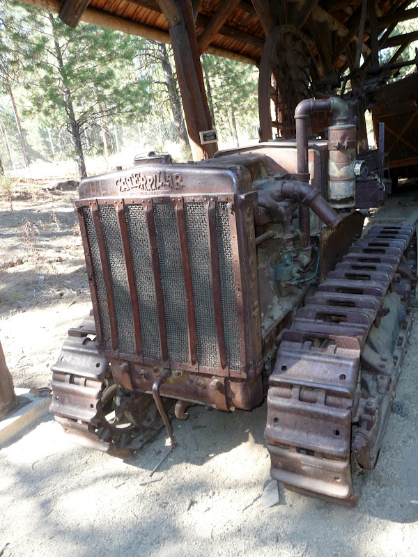
Later on, I went to the Collier State Park Logging Museum.  It’s about 40 miles north of Klamath Falls on Hwy 97. (Crater Lake’s south entrance is about 65 miles north of Klamath Falls.)  This museum is more of an outdoor display than the typical standard museum.  During the height of the summer they have state park employees that do demonstrations and give more guided tours of the area.  Well, as per my luck, I was two weeks late for all of that.  So I opted to borrow a map from the state park employee who was manning the information/gift shop and do my own self-guided tour.
Photo- Used to be drawn by horses and used to transport logs down the mountainside.
Photo- One of the first Caterpillars.
Photo- AND the $64,000 question is.... What's a RIP SNORTER?

The museum is set up with the history of logging in Oregon which started in the late 1860’s.  Logging in the late 1860’s consisted of hand tools and wagon-like vehicles where horses were used.  There were all kinds of examples of these items outside under pavilions.  Then, near the turn of the century steam came into being and steam-powered engine orientated machinery came into use.  These pieces of machinery were larger and were generally sitting out in the open.  Next, it was the combustible engine and the logging industry progressed on into our current time.  Most of these pieces were out in the open and on display. 
Photo- A restored original cabin of what the first loggers would have lived in.
There was also a cabin village area to show how most of the men would live while they were logging.  Most of these cabins were one room, with dirt floors, and hew from logs.  They were generally about 10’ x 14’ with a slanted roof.  It was a very interesting place to visit and it was just a very pretty day out.  It was nice just to be out enjoying it.

DAY 32—A Day Off and Family…
I know, I know… I had just taken off another day off just a few days ago and come on it can’t be that hard to be on a basically permanent vacation.  What’s up with that??!?  Well, I did need to catch up with some laundry, try to rearrange the inside of my car, and I wanted to do a bit of painting too; plus, I wanted to hang out some more with my Aunt Lindy too.   I managed to get a couple of paintings done and laundry got done too.  I hung out the whole day with Aunt Lindy and that was nice too.  It was a productive day. 
Photo- "Tickled Pink Shoppe"; Watercolor on 9" x 12" paper.
Based on shop I photoed in Portownsend, WA.
But let me say one thing about family; I think that there are more characteristics than just hair color, eye color, and general appearance that get passed on in a family.  What I’m alluding to is that I am now convinced that the genetic makeup for the open-mouth-insert-foot disease definitely runs in my family. Not that that’s bad but I noticed my family has a tendency to speak our minds and sometimes it’s not the most “Politically Correct” way of stating things.  I guess you could say that it’s probably a good thing that no one in the family is into running for political office because they would definitely be up that creek with no paddle and a ten foot wave coming at them.  But I will say that this same “disease” is part of the reason that makes me so dearly love my family too.  Sometimes, I think that it’s the small idiosyncrasies that make people, relationships and families so interesting; and thus, makes life very interesting too.  

Thursday, September 20, 2012

DAY 30 -Rogue-Umpqua Scenic Byway…

I planned on a scenic drive through central southern Oregon for the day.  Grant, Kimmie’s partner, had mentioned a nice route to drive but that it would take a whole day.  So I started out early; skipping breakfast and heading north out of Klamath Falls.  I passed by the Upper Klamath Lake and all of the pelicans.  I took Hwy 140 west after Rocky Point and went past Lake of the Woods and Fish Lake off into new Oregon territory for me.


Photo- Pelicans on the Upper Klamath Lake.

Shortly after passing Fish Lake, I took a right turn on to County Rd #821 on my way to Butte Falls.  I was driving through wonderful scenic forestland.  The road got rather curvy and I started to slow for the turns.  Before I knew it I was coming around a corner and BOOM!  There are cows in the middle of the road! COWS?!?!  Yes, I was in the middle of an open range area which happens quite a bit in Oregon but this was the first time I had actually seen cows on the road.  There were 7 large Black Angus cows in the middle of the road.  I slowed to a stop. 
Photo- HOLY COW!  They're in the road!

The cows just stood in the middle of the road.  HELLO! Move you big animals!  The car that was behind me started to honk and I followed suit; me being a City Girl had no idea what to do with cows in the middle of the road.  Low and behold; they started to move off the road.  Yeah!  As I drove by the cows just stared blankly at me.  I never realized how dumb cows could be.

I drove through the town of Butte Falls and after that the forestland was set back and fenced farms with green fields took up the foreground.  It was very pretty with horses and cows in the fields; with the periodic red barn or unpainted barn here and there. 
Photo- Farms with forest land in the background. Wonderful scenery!

I continued on; thinking that I was still on County Rd #821 but turns out I wasn’t.  I ended up coming out to Hwy 62 about 5 miles south of a cute small town called Shady Cove.  It was 15 miles south west of where I should have come out on Hwy 62.  But that was okay.  I went through Shady Cove where the cop sat right by the quickly reduced speed limit for the town.  I practically slammed on my brakes; to go from 55mph to 30mph.  I even managed a quick smile and way to the cop as I slowly went by.  But I HAD to stop for a quick picture of the pink Phil’s Frosty.  I later found out that it’s the place in Shady Cove to stop and eat ice cream or burgers.  There did seem to be a great deal of cars out front and it wasn’t even 11AM.
Photo- A hot spot and VERY pink place in Shady Cove!
Photo- The Rogue River as seen from a city park just north of Shady Cove.

I went along Hwy 62 where off to the right I could see the Rogue River.  It was a very scenic area with trees starting to change along the river and exposed rocks next to the road.  I drove past the small town of Prospect and on to Union Creek where I was told to definitely stop at Beckie’s Restaurant.  It was either their cinnamon roll or a piece of one of their pies that came highly recommended.  I stopped and I still had about 15 minutes of breakfast being served. 
Photo- A bird just taking off I saw on the Rogue River.
 
Photo- A MUST stop for thier cinnamon rolls or pie!
Photo- The inside of Beckie's Restaurant.

I opted for the yummy cinnamon French toast and hot coffee.  OMG!  It was dessert for breakfast!  It was as I was enjoying my breakfast that I over heard what sounded like Germans trying to learn to pronounce English words.  It was rather interesting listening.  As I was finishing my breakfast and looking at a map that I discovered I was close to a couple of sightseeing view sights.  I figured I could definitely use a bit of hiking to work off breakfast. 
Photo- Natural Bridge- where Rogue River runs under these lava rocks for 200ft. and then comes out.
Photo- Water comes out of Natural Bridge and there are side lava caves.

I did a bit of back tracking and went to the Natural Bridge parking lot.  The Natural Bridge is along the Rogue River and it’s where the river runs in lava tubes for about 200ft.  I grabbed my camera and off I went for the ¾ mile hike where there are viewpoints all along to see the Natural Bridge.  I read about the temperature of the water and how many gallons per minute that went through the Natural Bridge.  It was amazing and you could just hear the roar of the water as it went through the area.
Photo- Rogue River Gorge.

Next, I went by Beckie’s and discovered that while having breakfast I was about ½ block from a view overlook of the Rogue River Gorge.  I grabbed my camera again and off I went down the path.  This path however was packed with senior citizens.  It was a tour bus.  So I tried to slowly work my way through the group to where I could overlook the gorge area too. 

While trying to do that, the tour guide started talking to me.  He talked about how Oregon’s sportsmen’s, being so sports challenging orientated, used to canoe through this gorge area until about 2 years ago the state had to outlaw it.  He never heard of anyone dying doing it but he pointed out that it was seriously dangerous and he could imagine that some of they did die attempting it.  Why he shared that with me?  I’m unsure why he chose to share that information with me and he kept his voice down when he told me about it; so that none of the seniors could hear about it.  Strange.

Rather than turning east when Hwy 62 turned, I decided to continue on Hwy 230 up to Diamond Lake; a lake that I could see when I was on the trolley tour up at Crater Lake.  Yes, I was just west of Crater Lake and heading north.  I thought I want to see that lake from the shoreline.

I was about 6 miles north of there when I saw a sign that said—National Creek Falls with an arrow.  On the spur of the moment, I thought why not.  I turned the car.  I went down the road 3 miles to a sign with another arrow.  It said 2.5 miles on a one lane road with turn outs.  Okay, I thought I came this far.  I drove on the one lane road and only had a pickup truck that I had to wait for in a turnout.  I got to the next sign that pointed me off to the right to a parking area and another sign that had an arrow and said ½ mile hike.  I came this far and hoped it was really an actual waterfall but I continued on. 

Down the dirt path I went.  It hairpin turned down the side of a hill quickly and seemed to go back and forth again, and again, and again down the hill.  Wait a minute; this has got to be more than ½ mile by now.  BUT I continued on the path.  I got to the bottom and saw a couple with three dogs.    I went over a couple of logs and off to my left I heard and saw an amazing waterfall.  I could even feel the mist off of the fall. 
Photo- National Creek Falls a secret hidden off the road a ways.

I petted the dogs, of course, and talked with the couple.  They were from Grants Pass and came here to get away from the heat for the day.  It was as I was leaving that the guy mentioned that he saw a black bear about ¼ mile down on the road when they came in.  Oh, great I thought and here I am walking alone in black bear territory!  Go figure!  Note- It is recommended that you never go alone in black bear territory.  They are more likely to attack lone hikers.  Well, I decided to just book it back to my car, but I figured that if I talked to myself in two different voices that I could trick a black bear into thinking that there was more than just me in the area.  Yes, I really can be that silly and naïve at the same time!

Photo- The view of Mt Bailey on my way to Diamond Lake. 
I’m glad to say I made it back to my car safely and was not a headliner on a local TV news show.  Off I went back to Hwy 230 and continued north to Diamond Lake.  Diamond Lake is a wonderful lake to see from its shoreline.  It also is a very popular area.  There were quite a few boats full of fisherman out on the lake.  I also drove through quite a resort area with restaurant, cabins, and hotel. 
Photo- Diamond Lake a popular fishing place.

I swung by the gas station there to get a bit before I headed back to Klamath Falls.  It was funny because the attendant said that he had waited on a Jeep earlier in the day that was from Utah too.  He asked if it was Utah day and he didn’t get the memo.  I just shrugged my shoulders and smiled.  Then, off south I went back to Klamath Falls.

Sunday, September 9, 2012

DAY 19- Longview to Longbeach & Plenty of Cars...

I left the crummy Econolodge rather early.  The weather was cloudy, overcast and looked as though it could rain at any time.  I did a quick look at the Econolodge’s  “Continental Breakfast” and opted to just have coffee.  Nothing looked good and I questioned how fresh everything was.  I drove along the Columbia River on Hwy 4, a pretty drive.  I tasted the coffee after a while and OMG; can you say bad coffee?  The person who made it must not have been a coffee drinker at all.  It was that bad!

Photo- The drive along the Columbia River on Hwy 4.
I ended up stopping at a General Store in the hamlet of Skamokawa (please don’t ask me to pronounce this name!) It was right next to a little two room post office.  I thought while I was getting a coffee I would mail a couple of postcards too.  I tried the post office and it was locked.  So I went to the General Store and talked with the clerk as I got a cup of good coffee.  I guess that the postmistress had left out on her run and would be back later in the afternoon.  I guess I’d wait on the postcards.
Photo- The General Store where I got some good coffee and directions!

I continued to talk with the clerk and discovered a cover bridge near Hwy 4 that I was on.  She gave me directions to the turn off and said that it then again looped back into Hwy 4.  It sounded great to me.  She also told me of a couple other places to check out too while in Longbeach and later in Astoria all that were on my planned route of the day.
Photo- The covered bridge.
Photo- Signage for the Covered Bridge.
I found the turn off for the covered bridge and drove 2 miles to it on a winding country two lane highway.  It was fun driving across the covered bridge.  It was dark and had a distinct nose as you drive the car over the wood planking of the bridge.  It was one of another first for me; the first time I had driven a car over a covered wooden bridge. 

It was as I was trying to get back to Hwy 4 that I ended up getting a bit lost or so it seemed.  I ended up asking a farmer that was out by the road with his pit bull mixed dog named Spud.  I thought the farmer had said Bud, when I asked the dog’s name as I went to pet it.  The farmer corrected me twice and said that his name was Spud.  The farmer had a bit of a lisp.  “Oh,” I said, “like the potato!”  The farmer just looked at me like I had two heads.  I thanked him and continued on following his directions.  I ended up back on Hwy 4.
Photos- Art along the Art Interpretive Trail at Willapa National Wildlife Refuge. 

Next I stopped off at the Willapa National Wildlife Refuge just off of Hwy 4.It is tooted as being one of the most pristine estuaries in the U.S. and has over 260 square miles of water surface within its boundaries.  It has several bird and fish species; as well as Roosevelt elk, deer, river otters, bobcats, porcupines, raccoons, and black bear. I took the two hikes they have at the Headquarters: the Art Interpretive; a ¼ mile boardwalk with art displays, and the Cut Throat Climb; 2/3 mile that climbs up and down in a valley area next to a ridge.  It was a wonderful hike and just amazing that it was such a short distance from the road but you felt like it was miles.
Photo- The Cut Throat Climb Trail at Willapa National Wildlife Refuge.
Then, I got out to the stretch of land that had Longbeach on it and just wandered around.  I happened to stumble into the middle of the 29th Annual Rod Run to the End of the End of the World.  I drove by the fairgrounds area and there was a sea of fancy cars parked out on display.  There were tons of people and the road was backed up in both directions.
Photo- Backed up traffic and classic cars.

As I’m driving along, cars of all shapes and sizes are coming up in the other direction.  There were classic cars, old cars, Model T varieties, sports cars, and muscle cars; just anything you could imagine was there.  It was pretty amazing but what I thought was even more fun was watching the people on the side of the roads.  They were in chairs; whole families with their dog and kids in tow camped out with coolers and snacks.  The whole atmosphere was like the circus had come to town.  There was also a large abundance of misc. cars in all kinds of conditions that were parked along the road with for sale signs on them.
Photos- Car, car, and more cars!


I parked on a side street a couple of blocks over and I grabbed lunch; a bowl of delicious crab chowder at Captain Bob’s.  I sat down outside on a bench while I ate and also people watched.  It was all so fascinating.
Photo- Cape Disappointment.

Then, I swung by the beach for a bit.  After all, it's the longest beach being Longbeach.  Then, I moved onto Cape Disappointment about 4 miles from Longbeach.  It’s the lighthouse that served the area where the Columbia River goes into the Ocean a very treacherous area of water to navigate.  It was a short hike of ¾ mile out to the lighthouse.  I took a few pictures but now was getting to a point where I had enough sightseeing for the day. 

It was time to head on.  Off to Hwy 401, to the 5 mile bridge that crosses the Columbia River and also serves as a go between the state of Washington and Oregon.  About 2 miles out of the Washington side is when you are actually crossing into Oregon.  They have a sign above as you go through on the bridge.  Goodbye Washington and Hello Oregon!  And thus, I’ve finished one state of the lower 48.  I might need to pick up my pace a little bit now; but we’ll see.
Photo- Hello Oregon!