Thursday, September 20, 2012

DAY 30 -Rogue-Umpqua Scenic Byway…

I planned on a scenic drive through central southern Oregon for the day.  Grant, Kimmie’s partner, had mentioned a nice route to drive but that it would take a whole day.  So I started out early; skipping breakfast and heading north out of Klamath Falls.  I passed by the Upper Klamath Lake and all of the pelicans.  I took Hwy 140 west after Rocky Point and went past Lake of the Woods and Fish Lake off into new Oregon territory for me.


Photo- Pelicans on the Upper Klamath Lake.

Shortly after passing Fish Lake, I took a right turn on to County Rd #821 on my way to Butte Falls.  I was driving through wonderful scenic forestland.  The road got rather curvy and I started to slow for the turns.  Before I knew it I was coming around a corner and BOOM!  There are cows in the middle of the road! COWS?!?!  Yes, I was in the middle of an open range area which happens quite a bit in Oregon but this was the first time I had actually seen cows on the road.  There were 7 large Black Angus cows in the middle of the road.  I slowed to a stop. 
Photo- HOLY COW!  They're in the road!

The cows just stood in the middle of the road.  HELLO! Move you big animals!  The car that was behind me started to honk and I followed suit; me being a City Girl had no idea what to do with cows in the middle of the road.  Low and behold; they started to move off the road.  Yeah!  As I drove by the cows just stared blankly at me.  I never realized how dumb cows could be.

I drove through the town of Butte Falls and after that the forestland was set back and fenced farms with green fields took up the foreground.  It was very pretty with horses and cows in the fields; with the periodic red barn or unpainted barn here and there. 
Photo- Farms with forest land in the background. Wonderful scenery!

I continued on; thinking that I was still on County Rd #821 but turns out I wasn’t.  I ended up coming out to Hwy 62 about 5 miles south of a cute small town called Shady Cove.  It was 15 miles south west of where I should have come out on Hwy 62.  But that was okay.  I went through Shady Cove where the cop sat right by the quickly reduced speed limit for the town.  I practically slammed on my brakes; to go from 55mph to 30mph.  I even managed a quick smile and way to the cop as I slowly went by.  But I HAD to stop for a quick picture of the pink Phil’s Frosty.  I later found out that it’s the place in Shady Cove to stop and eat ice cream or burgers.  There did seem to be a great deal of cars out front and it wasn’t even 11AM.
Photo- A hot spot and VERY pink place in Shady Cove!
Photo- The Rogue River as seen from a city park just north of Shady Cove.

I went along Hwy 62 where off to the right I could see the Rogue River.  It was a very scenic area with trees starting to change along the river and exposed rocks next to the road.  I drove past the small town of Prospect and on to Union Creek where I was told to definitely stop at Beckie’s Restaurant.  It was either their cinnamon roll or a piece of one of their pies that came highly recommended.  I stopped and I still had about 15 minutes of breakfast being served. 
Photo- A bird just taking off I saw on the Rogue River.
 
Photo- A MUST stop for thier cinnamon rolls or pie!
Photo- The inside of Beckie's Restaurant.

I opted for the yummy cinnamon French toast and hot coffee.  OMG!  It was dessert for breakfast!  It was as I was enjoying my breakfast that I over heard what sounded like Germans trying to learn to pronounce English words.  It was rather interesting listening.  As I was finishing my breakfast and looking at a map that I discovered I was close to a couple of sightseeing view sights.  I figured I could definitely use a bit of hiking to work off breakfast. 
Photo- Natural Bridge- where Rogue River runs under these lava rocks for 200ft. and then comes out.
Photo- Water comes out of Natural Bridge and there are side lava caves.

I did a bit of back tracking and went to the Natural Bridge parking lot.  The Natural Bridge is along the Rogue River and it’s where the river runs in lava tubes for about 200ft.  I grabbed my camera and off I went for the ¾ mile hike where there are viewpoints all along to see the Natural Bridge.  I read about the temperature of the water and how many gallons per minute that went through the Natural Bridge.  It was amazing and you could just hear the roar of the water as it went through the area.
Photo- Rogue River Gorge.

Next, I went by Beckie’s and discovered that while having breakfast I was about ½ block from a view overlook of the Rogue River Gorge.  I grabbed my camera again and off I went down the path.  This path however was packed with senior citizens.  It was a tour bus.  So I tried to slowly work my way through the group to where I could overlook the gorge area too. 

While trying to do that, the tour guide started talking to me.  He talked about how Oregon’s sportsmen’s, being so sports challenging orientated, used to canoe through this gorge area until about 2 years ago the state had to outlaw it.  He never heard of anyone dying doing it but he pointed out that it was seriously dangerous and he could imagine that some of they did die attempting it.  Why he shared that with me?  I’m unsure why he chose to share that information with me and he kept his voice down when he told me about it; so that none of the seniors could hear about it.  Strange.

Rather than turning east when Hwy 62 turned, I decided to continue on Hwy 230 up to Diamond Lake; a lake that I could see when I was on the trolley tour up at Crater Lake.  Yes, I was just west of Crater Lake and heading north.  I thought I want to see that lake from the shoreline.

I was about 6 miles north of there when I saw a sign that said—National Creek Falls with an arrow.  On the spur of the moment, I thought why not.  I turned the car.  I went down the road 3 miles to a sign with another arrow.  It said 2.5 miles on a one lane road with turn outs.  Okay, I thought I came this far.  I drove on the one lane road and only had a pickup truck that I had to wait for in a turnout.  I got to the next sign that pointed me off to the right to a parking area and another sign that had an arrow and said ½ mile hike.  I came this far and hoped it was really an actual waterfall but I continued on. 

Down the dirt path I went.  It hairpin turned down the side of a hill quickly and seemed to go back and forth again, and again, and again down the hill.  Wait a minute; this has got to be more than ½ mile by now.  BUT I continued on the path.  I got to the bottom and saw a couple with three dogs.    I went over a couple of logs and off to my left I heard and saw an amazing waterfall.  I could even feel the mist off of the fall. 
Photo- National Creek Falls a secret hidden off the road a ways.

I petted the dogs, of course, and talked with the couple.  They were from Grants Pass and came here to get away from the heat for the day.  It was as I was leaving that the guy mentioned that he saw a black bear about ¼ mile down on the road when they came in.  Oh, great I thought and here I am walking alone in black bear territory!  Go figure!  Note- It is recommended that you never go alone in black bear territory.  They are more likely to attack lone hikers.  Well, I decided to just book it back to my car, but I figured that if I talked to myself in two different voices that I could trick a black bear into thinking that there was more than just me in the area.  Yes, I really can be that silly and naïve at the same time!

Photo- The view of Mt Bailey on my way to Diamond Lake. 
I’m glad to say I made it back to my car safely and was not a headliner on a local TV news show.  Off I went back to Hwy 230 and continued north to Diamond Lake.  Diamond Lake is a wonderful lake to see from its shoreline.  It also is a very popular area.  There were quite a few boats full of fisherman out on the lake.  I also drove through quite a resort area with restaurant, cabins, and hotel. 
Photo- Diamond Lake a popular fishing place.

I swung by the gas station there to get a bit before I headed back to Klamath Falls.  It was funny because the attendant said that he had waited on a Jeep earlier in the day that was from Utah too.  He asked if it was Utah day and he didn’t get the memo.  I just shrugged my shoulders and smiled.  Then, off south I went back to Klamath Falls.

DAY 29- Wildlife Refuge, Creamery, & a Pedicure...

The first thing I did was run by for an oil change at Oil Can Henry’s; an oil change chain that I had never heard of until I came out this way.  Unlike, Jiffy Lube they do not have a waiting room.  So you sit in your car and can watch via a TV what they are doing under your car and under your hood; plus chat with them as they do it.  It was something new to me.  Next, I went down the street for an express car wash where the clerk teased me about driving all the way from Utah for a car wash.  I laughed and told him it was because I drove all that way that I REALLY was in need of a car wash.

I wandered a bit around Klamath Falls; going out to the Upper Klamath Lake watching the Pelicans.  While I was further wandering, I happened to find an Oregon Visitor’s Center near the edge of the town.  I asked the lady about doing a short scenic drive because I needed to be back by 4pm for a pedicure appointment.  She suggested a drive to the south that was a loop that took me along the edge of the Lower Klamath National Wildlife Refuge.  She said that it was mostly a bird refuge.  Why not I thought I’ve already been watching birds today.
Photo- The beautiful stark landscape before I got to the marsh lands.

Thus, I went along Hwy 97 south and just before Doris, CA I took a left on to Hwy 161, about 17 miles south of Klamath Falls.  It’s a highway that runs right along the Stateline between Oregon and California; literally a straight shot.   The landscape seemed rather beautiful in its starkness.  But quickly the land changed to marsh lands.  Soon I was seeing ducks and egrets on water pond areas.  It was just amazing. 
Photos- The beauty of the marsh lands.


Photo- A white egret out in the marsh land.
Photos- White egrets in flight.


Photo- Some variety of stilts.

I turned south off of the highway into the Lower Klamath National Wildlife Refuge.  I took a quick hike to a platform lookout but it was the dry season and there wasn’t much going on because it was dry around the platform.  I opted to take one of the Auto Tour Routes which happen to be on gravel roads through the area; so much for having a clean car.  I stopped here and there and managed to see more birds. 

Warning these gravel roads are not designed to go much over 25 mph.  They are rather graded to ensure that you go slow and maybe that's so not to scare the birds?  The Auto Tour Loop is in two sections a short loop and a longer loop.  There's also several other little paths where its built up to walk into the marsh.  However, I would recommend that you wear long pants to walk through the tall grassy areas because there are a wide variety of other plants growing that might, or could, cause skin irritation.  So, in other words, me and my capris didn't get very far on some of these pathways.

I guess there are over 353 species of birds in the area but I only saw a few variety of ducks, some beautiful white egrets, a male pheasant and a female pheasant, flying eagles and hawks, and some variety of stilts(at least that’s what I’ve figured out from the pictures in the brochure that they had.  I’m not a real bird watcher as you can tell.)  It was rather fun.  
Photo- A brew pub named the Creamery?!??

Back in Klamath Falls, I grabbed a lunch at the Creamery which is a local Pub/brewery that was started in 2005 by two electricians who found the abandoned Creamery building and decided to start their business.  They’ve had some award winning micro brews and I really enjoyed their Hogsback Heffie which they serve with an orange; just the way I like it!  Oh did I tell you I got a kick out of parking between an Oregon Highway Patrol car and a Sheriff’s car just across the street.  I was just waiting to come out and find that my car got towed or some kind of note saying "Please behave yourself while you are in our neck of the woods", or something like that.  But I also kind of got a kick out of parking between the two with my out of state plates.  In the end, I came out and my car was safely still sitting there and intact.  Yeah!
Photo- The inside of this Creamery...

Next, I went to the Favell Museum in Klamath Falls.  The museum is based on a boy’s interest in collecting artifacts from our Western heritage; that boy being Gene Favell.  It started with Favell’s collection and has been expanded to include other collections and Western art from several prestigious and well-known artists.  It included quite a few of the Indian tribes of the Northwest and it was very interesting reading about the specific tribe customs.
Photo- My new toe look!

Shortly after 4pm, I found myself in a snazzy blue convertible car with my cousin Kimmie on our way to the nail salon.  I got my second pedicure ever and Kimmie was going to get a nail fixed.  It was fun!  Kimmie has been going to this same salon for over 5 years now and she was being teased by the employees.  I was cracking up and then we talked while we dried our nails.  Then when our nails were dry, we went next door to a new Japanese restaurant.  What fun!

Tuesday, September 18, 2012

DAY 28- Crater Lake...

The last time that I saw Crater Lake was about 8 years ago.  It was in the early part of July and there was about 4 to 5 ft. of snow still surrounding the lake.  I had pictures of myself, my dog Rocky, and my friend Kory posing with a snowman in our shorts with the lake behind us.  Sorry, the copies of those photos are buried somewhere in a little 5X5 storage unit in Salt Lake City.  So you see, I had some memory of seeing the lake before.

Photo- My first sight of Crater Lake from Rim Village. Wow!
But when I got to the Rim Village and got out of my car, the lake still took my breath away.  It was rather surprising to see it with no snow, and the brilliant blue color didn’t seem quite as brilliant as the last time I saw it.  I think that was due to a couple of factors.  The first is that there’s smoke in the whole area because of the fire up at Sister’s is still burning.  In fact, that fire has now doubled overnight and they are struggling to attempt to contain it.  The second reason it doesn’t seem as brilliant blue is because there’s no snow.  The contrast with the snow and the light that the snow throws off just makes that blue of Crater Lake all that much more dramatic.
Photo- The pretty scenery on the drive but
note smoke making distance sighting hard.

I explored around the Rim village very quickly.  Taking quite a few pictures but not really being able to catch the real awe of the place.  I took the short trail down to Sinnott Memorial Overlook and got an even more amazing view of the lake.  I tried not to look down because I got a bit dizzy from the height.  Inside and behind the overlook area there’s a room with background information about the lake.  I walked along the path area that runs along the lake in the Rim Village area.
Photo- The view from Sinnott Memorial Overlook.
Photo- A photo taken from the Sinnott Memorial Overlook
(without the roof.)
I really had hoped to take the boat ride that goes down on the lake but the day before was the last day of the season that they ran the boat.  Go figure!  So I opted instead to take a trolley tour guide that goes along the rim road.  It’s a little over a two hour tour; stopping along the way and the National Parks Tour Guide explaining things as we go along.  I went to the Rim Village Café and grabbed lunch while I waited for my time slot for the trolley tour.  I ended up having a conversation with a gentleman named Frank who was from Grant Pass.  He invited me to join him and his friend for a 3 hour hike up to Garfield Peak; a trail with a 1000ft climb.  I thanked him and told him I had already reserved a tour on the trolley.  All I could imagine that I would’ve probably slowed down him and his friend.
Photo- Me with Crater Lake.

The trolley tour around Crater Lake is very well worth the $25; and the guide that I had, Dave, was a former school teacher that was cracking puns and jokes along the way.  At one point, he even got out props of a rubber chicken and a huge pair of men’s underwear.  He would make up names of the Crater Lake scientists and what not like; Rockand Debris, who was an assistant to the Lake’s geologist. Dave, our tour guide, kept it interesting and seemed not to mind the hecklers at all.  In fact, one of the hecklers was a man from Texas and later he made a comment about sometimes people will come up with their boats pulled by large diesel trucks and expect to be able to fish on the lake with their boats.  Quite often, they are Texan’s wearing big ten gallon hats.
Photo- Inside the full trolley tour.

The tour guide then goes on to explain that access to the lake is near impossible. There are cliffs along the lake that vary in heights from 300ft to 1000ft.  The boats that are currently on the lake were helicoptered in and placed onto the lake.  They are stored and winterized just off to the side of the lake. 

Yes, there’s fish in the lake that were stocked into the lake years ago and in fact, they have fishing allowed.  It’s quite a hike to get down there to fish.  The fish are not native to the lake and some feel that the fish may have already made an impact on the ecology of the area but the only way to get rid of the fish safely would be to have them fished out.

What cause Crater Lake to be what it is?  Well, the tour guide explained that they believe at one time there was a HUGE mountain thousands of years ago and it had a volcanic episode.  Then, it collapse a bit on itself and over 800 years snow melting has filled it up.  But the interesting thing is because of a pumice area of rock in one of the cliff areas it maintains a certain height of water inside and will never overflow.  The pumice stone cliff area acts as similar as an overflow spout area works in a sink.  Thus, this lake will never overflow and evaporate.

The lake is one of the clearest waters in the world; and has done a clarity test that proved clear all the way down to 144ft.  The only other that comes close is Tahoe Lake which tested to 70ft. down.  The water is so clear because its source is only the snow pack that comes from snow.  There are no underground springs or rivers that run into the crater. The area gets on average 533 inches of snow.  In fact, the tour guide said he took about 800 years for the snow pack to fill the area.

Crater Lake is the 7th deepest body of water in the world at 1,943ft.  The tour guide then did a visual prop of showing how deep the lake was.  He took a picture of the Eiffel Tour, the Washington Monument, and the Statue of Liberty; one right above the other.  He said that there still would be 150ft of water above that.  Across one way the lake is 6 miles and is 5 miles the other way.  The tour guide told a story of how a well known female swimmer had swam across the Lake in 1939.  Of course, she swam the 6 mile distance, she didn't want to be considered a sissy.  (This tour guide had me cracking up!)  It took the swimmer nearly 42 hours to swim across it.

Did I mention I was glad to take the trolley tour around the lake because it saved me trying to drive it?  I’m a bit scared of heights and there were times where off to the side of the road looked like a sheer 300 ft. drop off.  It was more than what my nerves could’ve handled and I’m really not sure I could bike around the lake either because that would unnerve me.  But I was glad to have the bus driver being driving, then I could look up and across (not down) and I could enjoy it.
Photo- The gully area that runs along the road on the way up to Crater Lake.
That's called Annie's Falls down there but that's as close as you get.

After the trolley tour, I walked through the Crater Lake Lodge and found out that there was a talk being given by another National Park employee on the back porch area of the lodge.  The talk covered some of the same things that the trolley tour did, but went more in depth with the first visitors that came to Crater Lake.  It was interesting imagine how the early visitors came up the rugged terrain and they had to have camped out because of the distances and time involved.  Unlike my day where I could be 50 miles away, visit the park for several hours and still manage to be back at my Aunt’s for dinner.

Monday, September 17, 2012

DAY 26 & 27- Hanging with Aunt Lindy & Cousin Kimmie…

DAY 26- A Day Off with Aunt Lindy…
It had been awhile since I had taken a day off from my adventure and I needed to get something’s done.  Laundry needed to be done and some shopping.  So thus, I hung out with my Aunt Lindy the whole day.  We went shopping at the local Wal-Mart and then she took me for a drive around Klamath Falls showing me some of the sights and pointing out a black topped path where people walk, run, and bike.  Then, we hung out and were homebodies together at her house.  It was a nice day.

DAY 27- Lake of the Woods, Fish Lake, & Cousin Kimmie…
Photos- Of Cousin Kimmie's CUTE House....
 
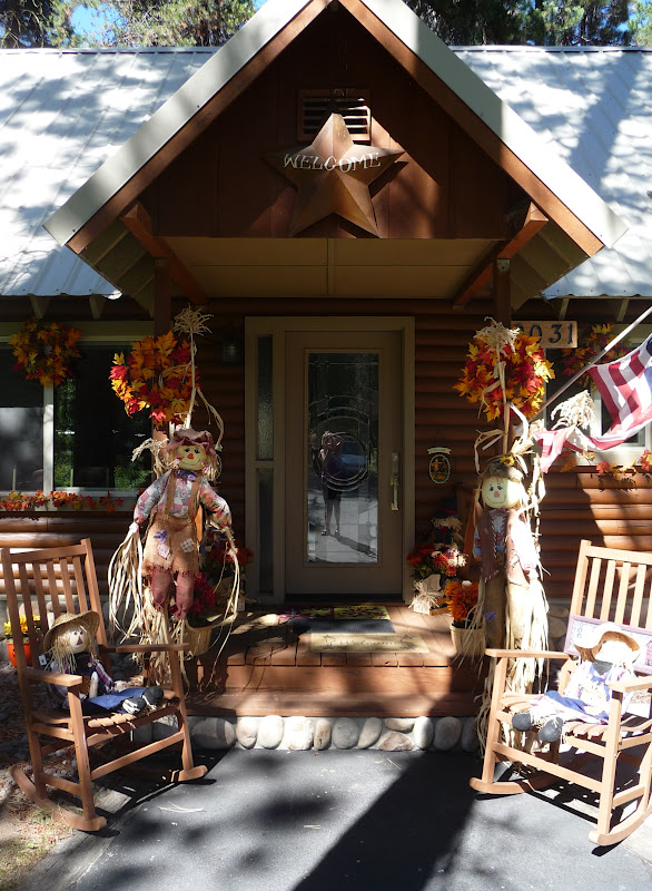
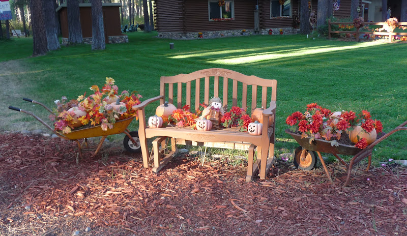
Aunt Lindy and I drove up to Cousin Kimmie’s house to spend the day doing a bit of sightseeing and visiting.  Kimmie's house is located about a 25 minute drive  outside of Klamath Falls.  Her cute log cabin like home is located in a community called Rocky Point.  Kimmie had her house all decorated for the Fall and it’s just adorable.  I gave Kimmie a belated birthday present of one of my watercolor paintings.  After I took a few photos of her cute house and we loaded up the truck off we went.
Photo- A happily married couple cardboard(?), Kimmie, Lindy & me.

We went for a late lunch/early dinner at the restaurant at Lake of the Woods. It’s a very scenic lake and resort area and they serve wonderful food too.  After eating we went walking around the resort area.  They had a wonderful gazebo, beach, swimming area, general store, and a small marina.  There were a lot of people enjoying the area doing all kinds of things like; swimming, sailing, boating, skiing, fishing and camping.  The resort has almost 20 cabins that can be rented out and RV sites with hook-ups that are available too.  We posed and took pictures around the resort; just generally being a bit silly.  It was fun.
Photo- Aunt Lindy ringing the bell.
Photo- The scenic --Lake of the Woods
Photo- Me on the beach with the Lake of the Woods and Mt McLoughlin in the background. 
Photo- Kayakers on the Lake of the Woods.
Photo- All kind of recreating going on at the Lake of the Woods.

Next, we drove around the Lake of the Woods, and got to see some of the summer homes that are built on the other side of the lake.  Some were huge and four stories tall and a few were smaller; and the views they had of the lake were wonderful.
Photo- The quiet beauty of Fish Lake.
Photo- Myself and Kimmie at Fish Lake with Brown Mountain in the background.

Then, we drove over to another scenic lake called Fish Lake.  It was a smaller lake with a great deal of camping sites but no resort area.  It was beautiful and quiet; just a nice relaxing place to hang and Grant (Kimmie’s fiancé) said that he loved to come here to fish because it was nice and quiet.  I could understand that and I watched some ducks dipping in to eat and splashing around. 

Photo- Ducks eating and splashing at Fish Lake.
We went back to Kimmie’s house.  We sat around enjoying her large lawn and visiting.  It was a wonderful way to finish the day.  Thank you Kimmie and Lindy!

Saturday, September 15, 2012

DAY 25- Newberry Volcanic Monument...

I managed to get in a quick waffle breakfast(YUM!) and then changed into my cycling gear.  I drove over where yesterday’s Happy Hour couple suggested I go.  It was out on the east edge of Bend and I was told it was a nice smooth 2-lane blacktop highway with a good shoulder that a great deal of the bicyclists in the area used.  The guy had teased that he’d be out there with Gatorade and possibly beer with Gatorade if I bribed him.  I just laughed because that’s not what I would need at 8am in the morning.  I was listening to a local radio station on the way over and there was a warning to limit your outdoor activities because the air quality from the fire over at Sisters.  I had hoped to get 20 miles in but I decided to do just a quick easy 7 miles; just enough to get the heart rate up.

I fueled up and headed south on HWY 97.  The goal for the day was to be at my Aunt Lindy’s by 4pm; the actual drive of which was about 2 and ¾ hours time.  It was basically a straight shot but I did have a least one stop that I wanted to make. 
Photo- Instead of the yellow brick road, I followed the red road.

I was planning to stop at the Newberry National Volcanic Monument which the Lava Lands Visitor Center is about 14 miles south of Bend. I turned in and flashed my National Parks Annual Pass at the gate.  Now I have a quick comment here; it seems that when you flash one of those passes at National places the attendant at the gate seems more attentive to you.  It almost seems like handing them the platnuim credit card.  The gal at the gate gave me a little time sheet and instructed me to park in the left lot but when my time frame came up to follow the red road over to the Lava Butte and also went on to explain several different parts and areas to the park; being very attentive but maybe that’s how all of those attendants are? 

I went into the visitors center and I found it very interesting because it explained the how and why that volcanic activity occurs and all of the results of it.  I thought it was especially wonderful and informative after seeing Mt Saint Helens.  It’s like I got a specific example of volcanic activity there at Mt Saint Helens but this was a more in depth generalized explaination of volcanic activity.  They had some wonderful displays and a 15 minute film that were very interesting. 
Photo- The Lava Butte that I drove around to the top.

Next, I was off on the red road for my 1.5 mile drive up to the top of the Lava Butte.  The road winds around and climbs up the side of the Butte and the view just gets better as you go up.  You can see for miles and miles.  There’s a very small parking lot at the top and I guess that explains the time sheet.  You are allowed a 30minute segment of time to be up there.  I walked into the exhibit which is actually a windowed room where above they show outside what the names of the mountain and buttes are.  I also took the quick hike around the top circumfrance of the butte.  There’s a small crater area at the top of the butte but they have a loose cinder rock path the goes around it.
Photo- An amazing but smokey view from the top of the Lava Butte.
Photo-Another amazing view with Mt. Bachelor off in the distance.
Photo- The plume of smoke fire from the Sister's fire.

Did I say the views were amazing?  They were and off in the distance I could see where the smoke for the Sister’s fire was at.  You couldn’t see Mt Jefferson because of the smoke where the two days before I could barely see the top of Mt Jefferson from the Timberline Lodge.  The fire was only 10% contained and there was concern because the winds had picked up and the temperatures were staying high during the day. 
Photo- From the Lava Butte Parking lot looking up to the forest service lookout
the upper part of building and viewing area around base of building.

There’s also a forest service lookout station at the top too.  It has served as a lookout for the forest service since 1928.  It made sense because of the unobstructed view.  I ended up talking with the forest ranger that was on-duty watch.  He was from Midvale, UT which is located in the Salt Lake City valley area.  He was heading home in another week; he said he was getting tired of all of this and waved his hand with a cigarette in it and rolled his eyes.

There are Lava River Caves about a mile south from the Lava Lands Visitor Center.  I drove right by it on my way back to getting back onto Hwy 97.  The lady at the visitor center mentioned rules because of the live bat population in the cave and that you could bring a flashlight or rent a latern from the small info. center nearby.  Live bats and dark caves--- hmmmm, really I think I’ll pass.

I again turned off to Hwy 21, which takes you to the large Newberry Crater.  The crater has two lakes that are used for boating and recreation.  The first lake I came to is called Paulina Lake and had a bit of that blue-green color that was similar to Lake Diablo.  The next lake was called East Lake.  There’s a great deal of campgrounds along the whole area and I could imagine it would be a wonderful place to camp.  There was even an area for a horse camp and there’s tons of hiking trails in the area too.

I was back off onto Hwy 97 and heading south.  I was in need of a fule up and it was past lunch time too.  I stopped at La Pine and fueled up and then drove through town.  There were the usual fastfood places like McDonald’s and Taco Bell but I wanted something more local.  That’s when I discovered the Red Rooster Café, as I neared the end of town. 

The Red Rooster is just open for breakfast and lunch only.  They close at 3PM and here it is 2:30PM.  I almost got the impression when I came in and sat at the counter  the older guy wasn’t happy to see me.  He said hi and handed me a menu with a wrapped up silverware.  He came back with a glass of ice water and just stood there waiting for me to order.  It was a bit unnerving.  But after a bit he did finally loosen up.  He reminded me a bit of an old billy goat gruff but a softy inside.  I asked him a couple of questions about La Pine and he answered them with short one word answers at first. 

I had to laugh when I asked what the economy in the area was based on and he said Nothing!  Then, he came quickly commented that a lot of the people in the area were retired from else where.  He had retired from the valley.  I didn’t ask which valley just nodded and let him talk.  He asked me a few questions and found out I would be in Klamath Falls area for few days doing whatever sightseeing with my Aunt and the next thing he was ring out the La Pine City map which had a map of the area on the back.  He was pointing out all of the lakes in the area that would be nice to see.

Just a little before 4pm, I was still about 60miles away from my Aunt Lindy so I called her and let her know that I would be about an hour later.  She said good because her and my cousin Kimmie were still vacuuming and cleaning before I got there.  I could hear Kimmie in the background yelling hi.
Photo- The beautiful sunset that I watched with my Aunt Lindy on her front porch.
I went to dinner with my Aunt Lindy to a cute little Japanese place on the main street of Klamath Falls where Aunt Lindy was a regular.  The server gave Lindy a bit of a hard time but it was all in good fun.  We had fun catching up and then walked back to my Aunt's house where we saw this colorful sunset.

Friday, September 14, 2012

DAY 24- On My Way to Bend...

I loaded up my gear and took my last look around Timberline Lodge.  It was a fun place to stay and the staff was just wonderful and very helpful.  I also really liked the idea of staying at a National Historical Site.  It was all worth the little bit of splurge.  I headed down the curvy 6 miles down to Hwy 26 and headed east.  The end goal for the day was Bend, OR.
Photo- One last look at Timberline Lodge while I got in the car.

It was quickly that I got over the mountain range that the landscape changed to a very dry arid area.  It looked like kindling for a fire; with tall grass that looked the color of wheat intermixed with juniper trees.  There was an abundance of dark lava rock croppings here and there.  There were a couple of sections where I drove through that looked like a fire had occurred within the last couple of years.  Tall tree stumps stood charred like lone soldiers on the horizon while others lay fallen.  There were an abundance of signs prohibiting fires or throwing cigarettes out of vehicles.


Photo- The amazing scenic viewpoint with a 300ft. drop
located just off a rest stop on HWY 20.

I had been told by a couple of people at Timberline Lodge to look out for Smith Rock State Park.  It’s a rock climbing mecca in the area.  While looking for that park, I stumbled upon the Peter Skene Ogden State Scenic Viewpoint.  It was a lava rock gorge area that went down for at least 300ft.  There was an older bridge that was part of a memorial highway and had a closed bridge that you could walk out on and look down.  I was getting dizzy from looking straight down.  But it was an amazing view and then there also was an old railway bridge that went over parallel to the other bridge.  Then, off on the other side was the bridge that the now Hwy 97 took over the gorge area.  It’s all part of a rest stop area for Hwy 97 and well worth the short walk to the overlook area.
Photo- Smith Rock State Park-- A mecca for rock climbers.

I finally found the turn off for Smith Rock State Park.  The road to it took you through a pretty valley area with horse ranches and farms with plenty of cows.  I saw a strange new sign I had never seen which looked like a person chasing a bike; strange.  I got to the park which was maybe 2 miles off the Hwy 20 and was kind of reminded of some rock areas down in southern Utah.  Some of these shear rock faces were about 200ft. tall.  I went down to the overlook area and asked where I could watch some of the rock climbers.  The lady said that it was too late in the day and that the rocks get too hot for the climbers to be on.  That was a bit of a disappointment.
Photo- Peacocks at the Peterson Rock Garden. 


Photo- Another peacock and the American flag done in rocks.
Photo- A wonderful bridge done in rocks.
Photo- A castle with its own moat at the rock garden.

The bar tender at Timberline’s Ram Head told me about a rock garden that was a bit off the beaten track and it was a bit run down but it might be a neat place to swing by and visit.  I stopped at the Peterson Rock Garden just south and out a bit from Redmond, OR.  A man did it as a little lifetime hobby of forming different sculptural pieces and putting gem stones on the outside of the pieces.  It kind of reminded me of a rock grotto that I had been to years ago in West Bend, IA.  I thought that it was a nice little place to stop and visit; all be it, maybe a little bit corny but still I enjoyed it.  Besides, the rock gardens there were about 6 to 7 live peacocks roaming the garden.

Next, it was finally on to Bend.  There was a great deal of hazy smoke as I got nearer.  I guess that there was a fire up by the Sisters area, a local mountain rec. area.  I wandered around the town and kind of totally got lost and turned around in their several round-a-bouts.  I think they have at least 10 of them in the city area and it makes it interesting finding your way around.  I just happened upon the Central Oregon Visitors center when I was looking through the Old Mill shopping Center; which is a cute new updated shopping center.  There was a bridge area and access to walking paths and bridges.  It was a very scenic little area with a great deal of people out enjoying it.  I got directions from the Visitor’s Center and went to the hotel.

Oooopps! I made the mistake and showed up a day early for my reservation.  I think I need to get a calendar!  The hotel was fully booked for the night but was nice enough to call a couple of other hotels in the area to find room for me.  I cancelled the next night’s reservation and followed a new set of directions to a La Quinta Inn in the south area of Bend.  Yep! I did it again and thank you Laura for pointing out that at least I’m consistent! J 
Photo- Bend's main street area.

Once I settled into the room, I was off to find some of the brew pubs I had gotten a map at the visitor’s center for.  I was off and back amid the round-a-bouts and really thinking I’ll be in need of a couple of beers after all of this. I was amazed that for a town the size of Bend (80,000) that it has 10 breweries.  I ended up McMenamin’s Old St. Francis for Happy Hour.  They have a Happy Hour?  Wow, that’s not something that you would find in Utah; course, you can’t get a pitcher of beer in most places in Utah.  McMenamin's is a 1936 Catholic schoolhouse in Bend that’s been retro-fitted to be not just a brewery, but also a pub, a bakery, a movie theater, an event space, and a hotel.  I guess that McMenamin’s is a chain that have done this with several other properties in the Oregon area but was told that this was the largest and best of them in the state. 

While enjoying my “Happy Hour”, I was listening (okay- eavesdropping) in on a couple at a different table.  It was a man and woman who had been friends for years and she was asking advice on what to serve a new boyfriend.  She described a dish and I was only half listening until he loudly said,” …with a side of bacon grease!”  I started chuckling and he told me he was sorry and that he would try that again when I was taking a swig of a drink.  I laughed and held up my empty beer glass and said hold on while I order another one!  We started chatting a bit after that while I finished my 2nd happy hour beer. 

After that I walked around in the main street and was basically blowing some time until a free band event was going to be playing there at McMenamin’s.  They advertise free concerts for all ages where you can purchase all kinds of beverages and even bring in food from the restaurant part.  The group that was playing was a wonderful folksy group mix with a female vocalist that had a voice that reminded me a little of Nora Jones.  It was just a wonderful group.  I ordered a beer and sat down in a chair along the wall.  The place started to fill up. 

I ended up striking up a conversation with a woman that sat next to me.  When the band took a break, Erie, yes like the Lake, showed me around and through to the back where there were fire pits where you could take your drinks and sit outside next to these fire pits.  It was wonderful. 

On the way, she even pointed out a 1937 picture of the Catholic school cheerleaders lined up holding stuff deer heads.  I asked if their mascot was a deer she said she didn’t know but she thought it was terribly creepy.  She and I talked for a while and finally it was time to go home for the night.  Erie, she was SO nice and walked me back to my car and told me an easier way to get back to my hotel.  Thank you gal.  I made it safely thanks to you!